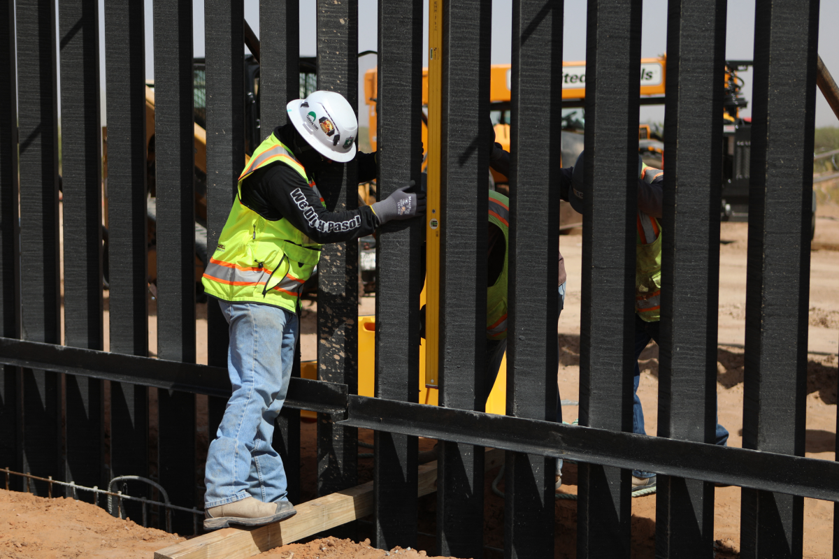
New panels for the border wall are being installed in West Texas, marking the start of visible construction on a 47.3-mile project in the Big Bend region as President Donald Trump’s administration expands its barrier network along the southern border.
U.S. Customs and Border Protection (CBP) said the first panels for the Big Bend 1 project in Hudspeth County went up on September 15, the Associated Press first reported.
Work is beginning amid legal challenges and resistance from landowners concerned about the federal government’s plans for the remote region.
The development gives new significance to CBP’s Smart Wall map, which records 232.4 miles of various border infrastructure completed since January 20, 2025, and shows hundreds more moving through design or construction.
Newsweek contacted CBP on Saturday morning via email for further comment.
Why It Matters
Trump directed federal agencies in January 2025 to construct temporary and permanent physical barriers supported by personnel and technology.
CBP said it is using $46.5 billion from the One Big Beautiful Bill Act to develop what it calls the “Smart Wall.”
The latest work extends that program into a part of Texas where rugged terrain and private ownership have historically limited continuous fencing.
CBP’s plans can affect landowners, border communities and visitors to public spaces through new walls, roads, surveillance equipment and vehicle barriers.
Key Points
- The first panels are being installed in Big Bend 1, a 47.3-mile primary-wall project in Hudspeth County.
- CBP reports 70 miles of new primary Smart Wall, 27.2 miles of replacement barrier, 42.1 miles of waterborne systems and 72.1 miles of secondary wall completed under its programs.
- Three Big Bend projects list 165.8 miles of primary wall, while two others provide for a combined 183 miles of vehicle barriers.
- Cameras, sensors, lighting, patrol roads and technology-only coverage form part of the wider enforcement network.
What To Know About The Big Bend Construction
Big Bend 1 is one component of CBP’s plan for approximately 175 miles of primary barrier across Hudspeth, Jeff Davis and Presidio counties.
Agency planning documents say the system may include surveillance cameras, lighting, fiber-optic and power cables, utility shelters, and access and patrol roads.
Work has moved forward first near Sierra Blanca, east of El Paso.
The other two primary wall projects shown on CBP’s map cover 62.2 miles and 56.3 miles respectively, but reporting published on September 18 said construction had not begun on those Presidio County sections.
Access to private land presents a significant complication.
Some property owners are challenging the administration’s use of eminent domain and environmental-law waivers, potentially leaving the government able to build on certain parcels but not others.
Newsweek spoke with No Big Bend Wall Coalition, an advocacy group that opposes plans to expand border wall infrastructure. Clara Bensen, the group’s communications director, told Newsweek over email that her group estimates some 400 landowners hold title to properties with Rio Grande frontage, where the CBP is looking to obtain rights to construct more wall.
“We have residents in every county observing traffic, and there were several reports of steel bollards being moved down to the border last week,” Bensen said.
“Putting together a significant, contiguous stretch of wall will still be a lengthy process across hundreds of landowners. With billions at play, contractors are highly incentivized to proceed with construction ahead of the midterms–whether or not it makes sense,” Bensen added.
Bob Krumenaker, a former Big Bend National Park superintendent who chairs Keep Big Bend Wild, said in The Guardian opposition had crossed party lines: “I’m very optimistic that there is a lot of support for Big Bend. This is a nonpartisan issue.”
A coalition of West Texas landowners has also filed a federal lawsuit shortly before the construction update, seeking to stop projects across the region.
Looking at concerns as work advances, Bensen said: “Flooding is an immediate concern.
“Economic concerns are also significant. Our entire region is highly dependent on tourism. Visitors come from all over the world to see this pristine landscape and to gaze at the Milky Way at night. Border barriers will corrupt the draw of this landscape.
She also noted that the area had been settled by indigenous tribes for thousands of years. “Many native people still live here today,” she said.
“A wall disrupts their current livelihoods, but also may bulldoze many sacred and historic sites along the river—forever,” Bensen added.
How The National Numbers Break Down
CBP has published a live interactive Smart Wall map that allows people to explore individual projects and view their construction status. You can see the live map here.
CBP’s map depicts a collection of different enforcement structures, not one uninterrupted wall.
The map uses color-coded lines to distinguish bollard, vehicle and waterborne barriers from supporting infrastructure and technology-only sections without a wall.
Red marks bollard barriers, orange vehicle barriers, blue waterborne barriers, purple system attributes only; light green technology and patrol roads without a wall; and dark green technology-only coverage without a wall or road.
The categories reflect the wider mix of barriers, roads and detection technology included in CBP’s Smart Wall program.
For new primary Smart Wall, the agency lists 357.4 miles under construction, 193.1 miles awarded and 70 miles completed. Another 417.2 miles of secondary wall are being built, while 88.5 miles are awarded and 72.1 miles are finished.
Waterborne systems represent another major category, with 375.2 miles under construction, 115.4 miles awarded and 42.1 miles complete.
Replacement of existing primary barriers accounts for a smaller share.
Those figures cannot simply be combined and described as a single length of new wall.
Primary fencing, parallel secondary structures and river barriers may occupy the same general locations.
Terminology matters too. CBP uses “under construction” when wall panels or waterborne barriers are being built or deployed.
“Awarded” may mean a project remains in design, although it can also cover early construction activity.
Plans For Parks And Protected Areas
CBP said it does not intend to install 30-foot steel bollard walls inside Big Bend National Park, Big Bend Ranch State Park or the Black Gap Wildlife Management Area.
Cameras, sensors and low-profile vehicle barriers are planned instead.
That distinction means construction in Hudspeth County should not be conflated with separate work proposed inside the national park.
CBP said it is coordinating with the National Park Service to maintain access to the Rio Grande and hiking trails while identifying cultural, historical and biological resources that could be affected.
The plans have drawn public protests in and around Big Bend National Park, including demonstrations at Santa Elena Canyon on August 12 and in Study Butte, Texas, on August 15, as residents and public lands advocates raised concerns about construction in the protected landscape.
Demonstrators gathered with signs opposing border infrastructure in one of West Texas’ best-known protected landscapes.
Technology Beyond The Wall
Physical barriers make up only part of the program. CBP plans approximately 538 miles of technology beside previously built barriers and about 205 miles of detection equipment near Big Bend vehicle barriers.
A further 167 miles of the border are expected to receive separately funded detection technology because terrain or remoteness makes wall construction unfavorable.
Combined with the Big Bend deployment, CBP says approximately 372 miles will be covered by technology alone.
What Happens Next
The immediate questions are whether construction extends beyond the parcels now available to the government, how pending litigation affects the schedule and when the remaining Big Bend sections advance.
CBP cautions that mileage may change as designs and routes are finalized. Its map also does not provide project-level completion dates, final costs or independent measurements showing how each barrier type affects unlawful crossings, smuggling or migrant safety.
Newsweek’s reporters and editors used Martyn, our AI assistant, to produce this story. Learn more about Martyn here.
Contact Newsweek editor on this story: Cristina Diciu and Edward Pearcey.
Update 09/20/2026, 06:54 a.m. ET: This article has been updated to include comment from Clara Bensen.